2026-10-08 · Feature
One trail per position source.
A vehicle with two receivers and an EKF has three opinions about where it is. The map used to draw all three markers but only one white breadcrumb trail, the EKF one, so when the opinions disagreed you could see the gap right now and nothing about how it got there. The map now keeps a trail for each source, drawn in that source's marker colour: cyan for the AHRS solution, blue for GPS1, violet for GPS2.
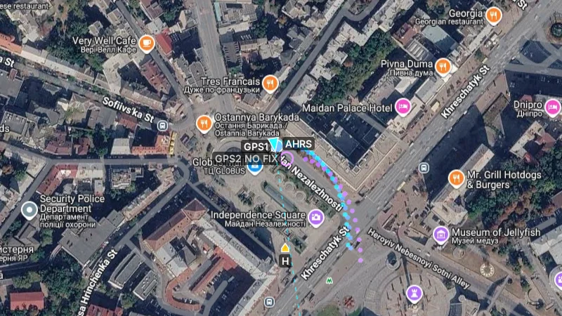
Each trail samples on its own clock and only while that source is usable. A GPS trail extends while the receiver holds a 2D or 3D fix and simply stops when it does not, so the end of a violet trail marks the moment GPS2 lost the sky. The AHRS trail keeps going as long as the EKF publishes a plausible position, which is exactly the picture you want during a jammed leg: the receiver trails freeze and the fused trail carries on alone.
The marker rule changed too. A GPS marker used to vanish the instant its fix dropped below 2D, which hid something useful: a jammed receiver keeps reporting coordinates, a last-known or dead-reckoned point, and sometimes nonsense from the other side of the planet. That position is now drawn as a hollow ring in the receiver's colour with a NO FIX label, so you can see what the receiver claims without mistaking it for a position the autopilot will fly on. Filled circle means fix, hollow ring means none.
Clear Track wipes all three trails together. The session snapshot written next to the log still records the AHRS trail, which is the path the aircraft actually flew.
Shipping in the next release · macOS / Windows / Linux